Trekking in Upper Dolpo offers a remote and adventurous journey through one of Nepal’s most isolated regions. Nestled in the rain shadow of the Himalayas, this trek features stark, arid landscapes, rich ancient Tibetan Buddhist culture, and breathtaking views of snow-capped peaks. Highlights include.
include Shey Phoksundo Lake, medieval monasteries like Shey Gompa, and encounters with traditional yak caravans. The trail crosses high passes such as Kang La and Saldang La, requiring good fitness and acclimatization. Upper Dolpo remains untouched by modern development, making it a perfect destination for trekkers seeking solitude, cultural depth, and rugged, pristine Himalayan beauty. Special permits are required.
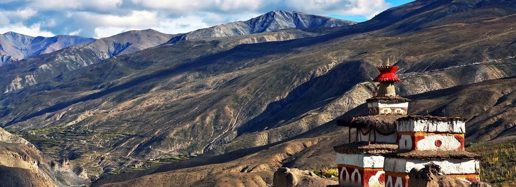
The Upper Dolpo trek is a unique and remote journey in the mid-western region of Nepal, nestled within the Shey-Phoksundo National Park. Located behind the mighty Mt. Dhaulagiri and close to the Tibetan border, this region shares deep cultural and spiritual ties with Tibet. Scattered across the landscape are centuries-old Buddhist monasteries that showcase the rich Tibetan heritage preserved in this secluded part of Nepal.
If you’re lucky, the trek also offers chances to spot rare and fascinating wildlife, including Snow Leopards, Blue Sheep, Himalayan Tahr, Jackals, Himalayan Mouse Hares, Yellow-throated Martens, Himalayan Black Bears, Himalayan Weasels, Rhesus Monkeys, Musk Deer, Langurs, and many more species.
The trekking days typically range from 6 to 7 hours, traversing continuous ascents, rugged hills, and high mountain passes reaching elevations of up to 5,500 meters above sea level. Along the trail, you’ll witness stunning natural wonders, including the majestic Kanjiroba Peak and the breathtaking turquoise waters of Phoksundo Lake.
Renowned for its high mountain passes, untouched natural beauty, and deep-rooted Tibetan cultural heritage, the Upper Dolpo region is a protected area. Trekking here requires a special permit, which must be arranged through Nepal government-registered travel agencies.
As a licensed and registered travel agency, Nepal Planet Treks & Expedition (P) Ltd is fully authorized to arrange the official permits and guide you to the hidden wonders of the Upper Dolpo Region. With our team’s expertise, in-depth local knowledge, and strong regional connections, we ensure your journey is spirited, fun, meaningful, and truly unforgettable.
Upper Dolpo Trekking is one of the most remarkable adventure routes in Nepal, offering raw natural beauty, rich Tibetan culture, and a unique remote experience. The best times for this trek are from mid-April to July, and again from September to mid-December.
Let us know your preferred travel dates, and we will customize the perfect itinerary for your Upper Dolpo adventure—designed around your schedule to make your holiday in Nepal truly special
When you enter in Tribhuvan International Airport (TIA), Nepal Planet Treks and Expedition’s airport representative will meet you and finish the formalities (Visa, etc), you have to verify our agent with a exhibit board at the entry gate. You will then move to the hotel. In the late evening, you will have a welcome dinner at a traditional Nepalese restaurant and see a Nepalese cultural program and get pleasure from fine meal. Overnight in Kathmandu.
Today, you will be go around cultural word heritage places in Kathmandu valley which is well-off for its culture as well as temples; the most holy Hindu temple of Pashupatinath, Swoyambhunath Stupa (monkey temple), the world biggest Stupa, Boudhanath, and historical Kathmandu Durbar Square, and astonishing Kumari extensively known as Living Goddess in Basantapur , Kathmandu. Overnight in Kathmandu.
We take up an air travel to Nepalgunj leaving Kathmandu which is located on the boundary to India. After reaching at the hotel in Nepalgunj, we can visit the Bageshwari Temple dedicated to Kali. Besides, in Nepalgunj, you can trip the bazaar, which has diverse stuffs on sale. Overnight in Nepalgunj.
Today, we will catch the flight to Juphal from Nepalgunj. As soon as we reach Juphal (2500m), we begin on our short trek to Dunai from Juphal. We walk downward via pastures and bypass all the way via a few houses to the small hotels at Kala Gaura lying in 2090m. After that, we go at the side of the river trail up to Dunai. We put our camp close to Dunai for staying overnight in Dunai.
Today, we will cross the large suspension bridge and we will go west, passing the hospital, and after that we walk next to the beach of the Thulo Bheri River to its mix with the Suli Gaad river. We go behind the trail to the east shore of the Suli Gaad. After around an hour, we enter at Kal Rupi and then stroll to Raktang (2260m). We will go across the west shore and pass many horses grazing regions over an edge to Jyalhasa. We will then pass through another bridge over the east bank, and walk to teashops and now traverse the Ankhe River (2460m). Also, we will turn on the old way that leads us to national park at Ankhe, and move via Pahela and Rahagoan communities. Now, the path moves to reach Phoksundo Lake and we go up to 2710m, and then we go downward on a wavering trail to Chepka (2670m). Tonight in Chepka.
We go after the route alongside the river climbing elevated than a small strip then move transversely the west side to go by a great peak and turn around to the east area once more. All along the stream at 2900m, our lane moves and makes a few climb and move downhill all the way through forests of larches, and follows upstream that will take you to the community of Renje which falls on the opposite side of the river (3010m). Overnight in Renje.
We go at the reverse side of the valley of Suli Gaad. We will move east and the way becomes narrower. We then go up over a peak and move descending to a bridge and go on trekking all along the valley foot to the union of the Pungmo Khola. Now, the trail leads us to Phoksundo Lake and we will also move to Shey Gompa. We climb in front via woods of cedar and reach Palam village (3710m). The entrance for Shey Phoksundo National Park situated at the southern area of the village. From here we can view a impressive 200m waterfall, uppermost in Nepal. The track moves along from birch forests to the deeply clear Phoksundo River. Then, we go up tenderly to Ringmo village, an attractive settlement with many chortens of mud as well as Mani walls. Just under Ringmo, we pass through a bridge and go to the north to Phoksundo Lake (3730). Overnight in Ringmo.
Today we have a rest for acclimatization today. We today might get ahead from juniper trees and come diagonally on the white Pal Sentan Thasoon Chholing Gompa, a go down Bon-po monastery put up 60 generations prior to lies on peak of the lake. Also, we will observe five other monasteries which have Buddhist paintings, statues, etc. Tonight in Ringmo.
Today we will walk on a pebbly edge as it goes around the western area of the lake. As we pass from side to side on a river, we can see the glacier moving downhill from the upper slope of Kanjeralwa. We then walk up to a crest at 4060m for a breathtaking sight of the lake with the snow-white peaks of Sonam Kang in the background. The path moves ahead and walks down from first to last blue pines, birches, to the western crest of the lake. The trail now makes way p to a long a big valley. We go after a cloudy path through scrub trees as well as prickly bushes. We will set our camp at Chunemba (3630m).
We will move all along the path that takes us to the north region via a glacial valley. We then cross the east bank of Phoksundo River. We go on trekking on the major gorge for another hour to get a hold to Kang Gompa. We walk upright from Kang Gompa and after that walk on the green rim. We will observe astonishing mountain views of Kang Chunne (6443m) as well as Shey Shikar (6139m). We will go after a apex lying at 4200m then the track moves down slowly on a stony trail to Lar Tsa. Here we locate our camp for staying overnight.
We cross a bridge and walk to the height at 4490m, after that we will go up a lush edge to a peak at 4640m. We afterward go down gently to Mendok Ding. We once more go up next to the river to a campsite at 4610m.
We will hike up to Phoksundo River, and after that we will twist north to the peak of Riwo Drugdra. We go at the back the more delightful pilgrim way diagonally to the Sehu La located at west of Crystal Mountain. Now, the trail descends to a slant to a green field beside the river valley and commences a series of long falling and climbing transversely all the way through edges. We now have an uneven climb to a peak (5010m) and another at 4860m. We begin descending to the Tar valley and we reach at Tsakang, an 800years old monasteries that are clinging exceptionally beside a cliff. The last way down today is on an extensive trail that takes us to a site where we will put our camp.
Today we have a rest for acclimatization today. Also, we may go crossways the river all the way through a bridge and go up via a big chorten and a huge ground to the Shey Gompa (4390m). The Gompa includes an antique Tibetan sway that tells tale about Shey Gompa plus Crystal Mountain. Overnight at Shey Gompa.
Leaving Shey Gompa, we will walk east and move crossways to get to an elevation 5010m where Shey La is situated. Now, we go round North and drop downhill before moving up another time to Namgung situated at 4430m. Overnight in Namgung.
We pass via the Namgung River on this day to reach Karang (4050m). After that, we will move down to Saldang at the plane of the shore of the river. Overnight in Karang.
We move downhill to Torak Sumdo situated at an altitude of 3670m where Polang River and Namgung unites and then hike crisscross to the north shore. We make way up to Yanger Gompa (3750m) and stroll next to the flowing river side valley. We camp next to the river at 4100m near to Mugaon.
We will walk up the valley to reach Mugaon today and make way up to the Mushi La at an elevation of 5030m. Then we will go down to Shimen village, we conclude our trek and place our camp above the village (4010m).
We walk downward to Shimen community at the elevation of 3870m and craft a far-reaching walk to the river all the way via a path to arrive at Pha at a altitude of 4090m. Then we will march to our final placefor today, to reach Tinje (4150m). Overnight at Tinje.
We trek leaving at the back the airfield on Tinje and stroll next to an intersection spot (4130m), where a high trail takes us to Tarap. We will move south to turn up at a camp on the shore of the river at Rakpa situated at a elevation of 4530m. Overnight at Rakpa.
We start on our day with an extensive way up to get to the Chharka La at a height of 4920m. We take the track downward and keep on trekking downhill to reach the valley at 4290m. We will walk at the back of the pleasing village of Chharka on the shore of Barbung River (4120m). Overnight at Chharka.
We will today walk up to an edge at 4380m and then go downhill another time to a river today. We go following the partition situated southward, and move up along the flat valleys on an uneven trail. The ravine narrows, we then come to a big plain and walk up to the campsite at Norbulung at 4750m.
We start climbing to a yak grazing land at Molum Sumna placed at a height of 4860m then stroll to a peak at 5130m. We make an extensive stroll across meadows to the base of the Sangda La. Next we will have a long, steep final ascend to the pass at an elevation of 5460m. We put our camp in Sanga Phedi for overnight stay.
We rise to a lower Sangda La located at 4990m, after that we will move down to the community of Sangda Ghunsa (4190m). We go descending to the Chalung River, going crossways at 3750m, and after that make way up through the reverse bank. We afterward go to a set of vertical way down to a river at 3580m. We have one more climb to the Sangda. Overnight in Sangda.
We make way up the hill at the reverse side of Sangda and make go crosswise nine edges to a last crest at 4280m. We then move downward into the Kali Gandaki valley, after crossing under elevated cliffs and moving downhill to the big community of Dhagarjun at 3290m.
Leaving Dhagarjun, we will return to Jomsom taking around 3 hours. Overnight in a lodge.
Today, after finishing our breakfast we will soar from Jomsom to reach Pokhara and will have extra time in afternoon in Pokhara and go around the valley. Overnight at hotel in Pokhara.
We can then fly back or take a vehicle to reach Kathmandu from Pokhara. In the evening, in Kathmandu we will have farewell dinner together. Overnight in Kathmandu.
Our journey ends on the 28th day. Our representative will guide you to the airport and present farewell greetings.
Your Start Date is the day you land in Nepal, and your End Date is when you fly home.
If the set Upper Dolpo Trekking group dates don’t suit your schedule, we can offer alternative dates upon request.


 (18)
(18)  100% recommend (0)
 (0)
(0)